Put your B&G data on your iPhone
B&G Zeus, Zeus S and Vulcan displays stream NMEA 0183 over Wi-Fi. SailStats reads that stream and shows your wind, depth, boat speed and heading on a dashboard you lay out yourself — at the helm, on the rail, or below. Your plotter carries on working exactly as it does now. Free, and nothing on the boat is changed.
Set it up in five minutes
Turn on the display's Wi-Fi
On the Zeus, open Settings → Connectivity and enable the Wi-Fi hotspot, or join the display to the boat's existing network. Older firmware calls this menu Network or Wireless.
Join your iPhone to that network
The boat's network, not the marina's and not cellular. On a Zeus S you set the hotspot name and password yourself.
Find the display's IP address
On a Zeus S it's under Settings → Boat network → Ethernet.
On other firmware it may sit under Network, or beside the
NMEA 0183 settings. It usually looks like
172.22.x.x — and it can change between sessions, so
check it rather than remembering it.
Enter it in SailStats
Settings → Connection, type the IP address, tap Connect. Leave the port at 10110 unless your display told you otherwise — most never show a port at all.
Say yes to local network access
iOS asks once. If you decline it, nothing can connect and the error you get afterwards won't mention the permission.
Which B&G displays work?
| Display | Works | How |
|---|---|---|
| B&G Zeus³ | Yes · tested | Wi-Fi, TCP, port 10110 |
| B&G Zeus³S / Zeus S | Yes · tested | Wi-Fi, TCP, port 10110 |
| B&G Zeus² | Yes | Wi-Fi, TCP, port 10110 |
| B&G Vulcan | Yes | Wi-Fi, TCP, port 10110 |
| B&G Triton² / Nemesis (instrument displays) | Via the plotter | They feed the NMEA 2000 backbone; the Zeus or a gateway puts it on Wi-Fi |
Marked tested means verified on a real boat, not inferred from a spec sheet. Simrad NSS and NSO evo displays and most Lowrance HDS and Elite units behave the same way — the full list, including Garmin, Raymarine and 13 Wi-Fi gateways, is on the compatibility page.
Do I need to change anything on the plotter?
No. SailStats is a read-only listener on a stream the display already sends. Your charts, autopilot, radar, instrument calibration and alarms are untouched, and unplugging your phone puts everything back exactly as it was.
Some firmware has an explicit NMEA 0183 output switch. If yours lists one, turn it on. Many current displays stream by default and show no such setting at all — that's normal, not a problem.
What data will I actually see?
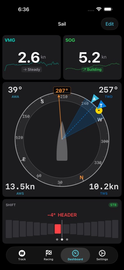
Whatever your boat actually measures. This is the honest limit of every app in this category: if there's no masthead unit, nothing can show you wind. SailStats parses 18 NMEA 0183 sentence types:
| Sentence | What you get | Needs |
|---|---|---|
MWV | Apparent and true wind angle and speed | Masthead unit |
MWD | True wind direction and speed | Masthead unit |
VHW | Boat speed through the water, and heading | Paddlewheel / speed log |
VPW | Speed parallel to the wind — VMG | Wind + speed |
VTG | Course and speed over ground | GPS |
RMC | Position, SOG, COG, time, magnetic variation | GPS |
GLL | Position and time | GPS |
HDG HDM HDT | Heading — magnetic, true, with variation and deviation | Fluxgate or satellite compass |
DBT DPT | Depth, with transducer offset where sent | Depth sounder |
MTW | Water temperature | Temp sensor |
RSA | Rudder angle | Rudder feedback |
XDR | Heel and fore/aft trim | Motion sensor |
RMB BWC XTE | Active waypoint, bearing and distance to it, cross-track error | A route active on the plotter |
Where the standard offers both a true and a magnetic field, SailStats prefers the magnetic one, so bearings agree with the compass you're steering to rather than disagreeing by the local variation.
How is this different from the B&G app?
They do different jobs, and there's no reason not to have both. Navico's own apps mirror the plotter screen and handle charts and software updates — they're an extension of the display.
SailStats is an instrument display you configure, plus everything that happens after the sail: every session recorded with its full instrument history, course performance, a start-line timer with line bias, and a fleet replay where everyone's tracks run together on one map. It's aimed at the question "how did that go, and why", which a plotter mirror can't answer.
Can I run SailStats and another app at the same time?
Sometimes. Some Navico firmware accepts only one NMEA client at a time, so if a second navigation app is holding the connection, SailStats will connect but see nothing. Close the other app and reconnect. This is a limit of the display, not something an app can work around.
What if my boat has no wind instruments?
SailStats still does a great deal. Your device's own GPS gives position, speed over ground and course over ground — enough for track recording, start-line timing, race replay, fleet racing and most speed analysis. You don't need to connect anything at all to get value out of the first sail.
What an instrument feed adds is wind, depth, boat speed through the water and a proper compass heading — and with real wind data, the point-of-sail breakdown that tells you how you actually went upwind versus downwind.